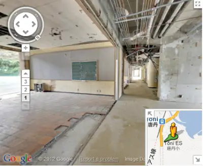
Google, a year ago started digital archiving project, a street view imagery that provided an overview of the damages done in the North-eastern Japan that were affected badly by earthquake and tsunami in March 11, 2011. After travelling through the affected regions, the tech giant has now released 360-degree panoramic imagery of those regions for views on Google Maps.

Tsunami 2011 Images
The images give us an idea of how natural calamities can transform dwelling communities into a disaster. Google Street View in Google Maps provides an overview of just that.
Back in July, we announced our initiative to digitally archive the areas of Northeastern Japan affected by the March 11 earthquake and tsunami. Today, we’re making good on that promise—after driving more than 44,000 kilometers through the affected regions, 360-degree panoramic imagery of those areas is now available through the Street View feature in Google Maps.” said Kei Kawai, Group Product Manager, Street View.
There are photographs of over 30 buildings and they can all be viewed via a special website called “Build the Memory,” where you can easily compare before and after shots of the towns changed by these events. Google has also launched “Memories for the Future,” a site that too compares before and after photos of the areas most heavily impacted.
To complete the project, Google worked in co-ordination with four city governments in the Tōhoku area. The timing of the project was crucial as there was a strong debate in areas affected as to keep the buildings up as a permanent reminder of the tragedy or tear them all down.
The local governments after days of consultations with their citizens decided to proceed with the work of demolishing the buildings. Learning this, Google quickly moved to photograph the buildings before they were started to be dismantled.
More details can be had at Google.
http://youtu.be/_WpweafY3Nw
Leave a Reply