I had some time back, talked about ChronoZoom: A Timeline and Visualization Tool from Microsoft Research. Yesterday, I talked of Data Hub. In this post I am going to discuss yet another innovative tool from Microsoft called as FetchClimate. As the name goes FetchClimate fetches and provides you climate details about any location on the earth in the simplest way ever. Here’s how:
FetchClimate
FetchClimate is an intelligent, fast and fluid climate information service that unifies all the climate data available in the past and present. This service is not just about the weather forecast rather it provides information about climate and other aspects of the environment such as Air temperature, precipitation, soil moisture and more. It can get you the climate situation for a particular geographical location between the years 1900 – 2012 and counting. That looks impressive and the reason to this is the large data available for almost any part of the world.
Using FetchClimate
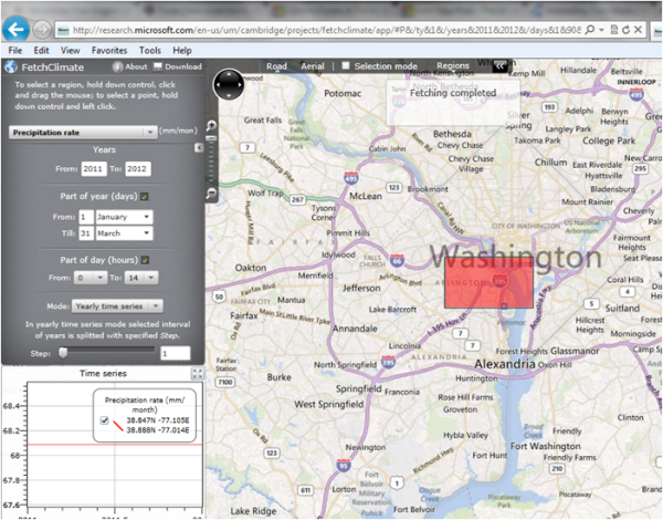
There are multiple ways to get started with FetchClimate and one of the simplest is using the FetchClimate web portal. It has the full screen world map similar to the Bing Maps. The display pane is on the top left part of the screen, navigation or the location exploration is just like any other Map service – using mouse scrolls.
Step 1: On the panel select the data you need, that is the type climatic information, the time span in years, months and time.
Step 2: Scroll the mouse to zoom into appropriate location on the map. Select the area by holding “control” key and click and drag the mouse. Click the “Click here to fetch data” button right below the options screen. This way it generates a graph containing all the information and data.
Also this climate service can be accessed using few lines of code your .NET application and using command prompt commands. FetchClimate has a well documented user manual for the programmers that can help them integrating this service in their applications.
Here is the lineup of features that FetchClimate offers:
- Air temperature, precipitation, soil moisture and more.
- Spatial grids or time series; yearly, seasonal or for just a part of a day.
- Intelligently selects proper data source for each request; but can be forced to use a particular data set, too.
- Interactively compose a request; or import request parameters from a file.
- Present the result graphically or export it to a file.
- Use dynamic web interface, call it from a command line or from your program.
Many environmental science research and applications require information about climate and other aspects of the environment. The good news is that a huge amount of climate data is available, covering the whole of the Earth surface. FetchClimate certainly help people to fetch this data sets in a simple way.
FetchClimate was supported by Microsoft Research Connections and build in collaboration with Moscow State University.
You definitely have to check it out. Explore FetchClimate online here
PS: I noticed that FetchClimate gives best results when used with Internet Explorer.

Thank you for the link. it’s a huge data base.